Showing posts with label gps. Show all posts

Tuesday, April 12, 2022

What is the difference between drones and missiles?

Russian Iskander missile (Wikipedia)


Missiles are easier to use in war crimes. The missiles need only two coordinates the launching point. And the point where the target is. The missile crew will give the target coordinates to the missile. And then the GPS/GLONASS system tells the missile its location and the distance to the target. When the target is in range, the system simply tells, that it's time to shoot. 

The problem with that kinds of missiles is. They need to update their target's position all the time if the missile wants to hit the moving targets. The CEP (Circular Error Probability) depends on the accuracy of the positioning system. Things like radar and image (or imaging infrared) homing missiles require the position of the target and then the GPS or inertial navigation system will drive the missile to the point, where its trajectory starts to turn to the ground. 

Then the seeker must see the target. If the seeker doesn't see the target the AI must decide does it detonates the missile in airborne. Or would it allow it to impact the ground? The thing is that AI-based imaging infrared systems are the new things and the computer code that is needed is complicated. And the most usual way to make a missile fly to its target is to use GPS/inertial navigation. 

If there is no optical seeker the operators would not even know where they shoot their missiles. So the fault, if the missile hits civilian targets, is the person who gives coordinates to the guidance system. 


Things like UCAV (Unmanned Combat Aerial Vehicles) are made against highly mobile missile systems. The combat drone can patrol for hours or even days and search the targets. And missile systems are the primary objects for small and lethal anti-tank missiles. 

Those drones can observe the ground operations but they are capable to destroy both anti-aircraft and short-range ballistic missiles. They can use along with the manned aircraft or alone against all ground targets. The thing is that the controller of the system sees the target. And if there are some civilians those drone operators should see also that thing. 

The thing is that the high-flying low-enduring drone is always quite a hard target for ground-based systems. The piston engine leaves a very low infrared signature. The question is why Russian military have not those systems?
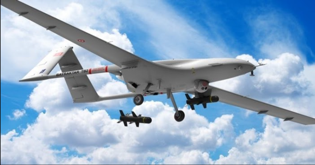
Bayraktar TB-2 (Redditt)


The answer could be that the drone can use for so-called "surgical strikes". And that means drones are useful also things like assassination missions. The thing is that drones are effective and dangerous tools is that they can be almost everywhere. Small UCAV drones can carry to operational areas even in the trunk of the car. 

And they can leave to the attack position. The drone can be a quadcopter or it can be aircraft-shaped like Boeing Dominator. So when the target is coming to the operational area it will go airborne. The aircraft-looking drone can use a balloon for lift-off. 

And the operator can make that strike from a long distance. That thing makes them very frightening. And the weapon systems must be frightening because they deny the attacks from foreign countries. The purpose of the military system is to put fear in the mind of enemies. And that thing makes all successful weapon systems rough, brutal and shocking. 


Sunday, April 10, 2022

GPS and artificial intelligence are the ultimate combinations.


Artificial intelligence along with the GPS can make many things more effective. Artificial intelligence can observe warehouses, and if storages are low the AI can order replacements. The AI can also observe where the cargo is traveling and locate each point of thing by using the GPS. The GPS can install on the computers like laptops. And that allows the authorities to know all the time where their stuff is. 

The GPS can install in cars and car keys and the GPS can help to locate almost everything that flies or travels by railroads and what is at the offroad conditions. The GPS can help things like robots and drones take their places in the entireties like drone swarms. The GPS allows the robots to navigate freely in their operational area. 

The GPS is one of the central components in modern military systems. The GPS can deny the attempts to steal the grenades. But the same GPS can be integrated into the guidance systems of those grenades. The GPS-guided grenades and bombs are extremely high accurate weapons. 

The GPS makes it possible that the smart ammunition can detonate precise right point and right altitude. If the mobile howitzers and the GPS systems of the grenades are communicating the howitzer can shoot the target at just the precise right point and moment automatically. If the Javelin-type missiles are equipped with both AI and GPS. That thing makes it possible to shoot them over the buildings. 

The image of the target. And its location can be given by many separate systems. From satellites to man-portable cameras or even mobile telephones can use for that purpose. When the missile flies to the target its optical seeker looks at it. And when the visual seeker gets a positive ID the optical image-homing system will drive the missile to the target. 

The accuracy of the GPS depends on how often the system updates the target's location. In GPS-based weapon systems, the accuracy of the GPS is the key element. The best choice is to use the small-size lightweight GPS that is put on the top of the tank. The fast-updating GPS makes it possible to shoot moving targets. Or put on the clothes of the targeted person.  

That GPS can install in the right place by using small robots or agents that can put that GPS in the target's pocket. In the last case, the shooter can use the rifle where is the GPS for targeting the target. 


The GPS is the key element also in the most modern rifle grenades and smart rifles. If the location of the enemy position is known the shooter can simply shoot the intelligent rifle grenade over the target. And there the system will detonate that ammunition. The pressure strike of the RDX explosives is extremely powerful. 

The GPS can also make it possible to aim the rifle in the right position. The modern GPS is very small and the bullets can also be homing. They can be equipped with GPS. And they can fly to the target by using a similar system to the GPS-guided grenades. 

If the system knows the location of the target. And the rifle makes it possible to aim the rifle by using a simple screen. There is a diagram that the shooter can use for aiming the weapon. 

Unless a well-known tracking point, this system uses two GPS. The shooter will get the distance and position to the target. This system can use in the GPS telephones. 

The aiming image can make on the screen of the telephone. Or the shooter can use the screen in the smart scope. The bullets can be small-size missiles that are equipped also with GPS. 

When the weapon is in the right position two crosses on the screen are at the top of each other. And that makes it possible to shoot the target with very high accuracy. That thing makes the sniper rifles and small munitions more lethal than they have ever been before. 

Images: Pinterest


https://likeinterstellartravelingandfuturism.blogspot.com/

Friday, December 10, 2021

The new type of logic bomb is turning physical.

 The new type of logic bomb is turning physical.


A logic bomb is a computer virus that destroys databases or entire systems. Those computer viruses can be activated by data or by giving some stealth command to the targeted system. That command might be some kind of ALT+255 type order that activates the virus code. 

The traditional logic bombs can slip into the systems in the updates. In some scenarios, that malicious code would be masked as the GPS signal or delivered between GPS packages. 

Or those logic bombs can be hidden in components. If it is remotely-activated malware code in the kernel of the microchip, that thing can cause very bad things. It can format the microchip. And without that thing the microchip is useless. 

But there is the possibility that the malware or logic bomb turns physical. In extreme cases, logic bombs or malware code slips in the nuclear enrichment plant. Or even nuclear reactors. In enrichment plants, the malicious code can simply accelerate centrifuge too high speed. If the rod of the centrifuge is too long that thing can cause a nuclear explosion. Especially, if the centrifuge is handling plutonium. Like it does in nuclear weapon production. 

If the speed of the centrifuge is too low in nuclear weapon production. That thing causes that there is a too low count of plutonium and the nuclear weapon doesn't explode. The centrifuge is used as the separator for uranium ore. The malware can force to shut down the nuclear reactors but that kind of software can cause the china syndrome where the nucleus of the reactor is melting. 

But the malicious software can also cause problems for producing things like fuels or explosives. There is the possibility that in the production process of explosives in the process slips too much nitric acid. And that turns it too hard. Or the malicious software would disturb the relationships in chemicals that are used for fuel. 

The new type of logic bomb is targeted to disturb the manufacturing process of the 3D-based printing technology. Those logic bombs can also disturb all work that is made by using automatized assembly lines. If there is a discontinuity in welds. 

Or internal structure in the 3D-printed machine parts like turbine wings that thing can be destructive. There are many points in the physical part's production processes where the logic bombs can affect. 


https://scitechdaily.com/new-cyber-protections-against-stealthy-logic-bombs-targeting-3d-printed-drones-prostheses-and-medical-devices/


Image: https://scitechdaily.com/new-cyber-protections-against-stealthy-logic-bombs-targeting-3d-printed-drones-prostheses-and-medical-devices/


Monday, November 22, 2021

The GPS-free navigation

 The GPS-free navigation


The GPS-system is playing a vital role in everyday life. That system is required in many everyday applications. But in the military area, the GPS is even more important than people even imagine. The GPS-guided bombs allow the aircraft can close their target freely from any direction. 

The recon satellite must only locate the target from any point of Earth. And then it must just deliver that point to the attack systems. And then the GPS-guided system will fly the aircraft to the target. 

The GPS makes also possible to locate own ground troops very accurate. And then the attack plane can attack the enemy with pinpoint accuracy. And this is the reason why the GPS satellites are the primary targets for the ASAT (Anti-Satellite) weapons. And that is the reason why GPS-free navigation is under development. 

One of the simplest versions of the GPS-free navigation that can operate without GPS is the inertial navigation system. If the inertial navigation systems are operating as series the autopilot can fly the aircraft by using quite complicated routes. If the aircraft can use pre-planned speed, altitude, and turning directions. The GPS that operates by using a series of waypoints can be useful. When the aircraft's speed is known the distance or the length of the vector that it travels is easy to calculate. When the aircraft is reaching the turning point, the system turns it by using the pre-ordered angle. 


Smart weapons can use the inertial navigation system connected to TERCOM-navigation. Engineers created that system originally for cruise missiles. But it can use in regular aircraft and drones. 


The TERCOM system uses the images for traveling to the target. The satellites or other recon systems would take the images of the route that the missile or aircraft should use. And then the system compares the images stored in its memory with the data that its camera and lidar scanners bring to the system.

The inertial and image homing systems can use to aim weapons in cases that the GPS is unable to operate. The system must just need photographs of the target. And then the weapon would deliver at the flight range. Then the imaging seeker locates the target and the system selects the right attack angle and other parameters that are made precisely to a certain type of target. The hardened target requires 90 degrees of the hit. 

If the robot operates on another planet the GPS that records the movements is enough. In the case, that the robot will go to the place where it cannot drive through it must only retake the same movements that it made in the opposite order. This kind of system can use in deserts and other planets. But the GPS-free navigation is required also in robots that are working in everyday life. 

If the navigation and communication between the robot and control center are jammed in the places like tunnels the robot car must not drive backward when that thing is happening. It must drive independently and safely to the area. Where it can reconnect itself to the network. 


https://en.wikipedia.org/wiki/Inertial_navigation_system


https://en.wikipedia.org/wiki/TERCOM


https://thoughtsaboutsuperpositions.blogspot.com/


Tuesday, November 16, 2021

Russian new antisatellite test endangered the ISS crew.


Russia made a new ASAT (Anti-Satellite) test. This test is made by using debris that is launched against the trajectory of the target satellite. This kind of ASAT weapon is simplest as possible. The last stage of the rocket will load by using metal balls or other debris. 

Then that debris will launch against the target satellite by using the small detonator behind that ammunition. The ASAT tests are the new demonstration of the will to create weapons that deny the use of satellites. 

The satellites have many missions in the military world like targeting, locating, and communication. If the ASAT destroys GPS (or GLONASS), recon and communication satellites. That thing will make military operations more difficult than they would be. The nuclear forces would not have their launching codes if those satellites are destroyed.

And also drone swarms and smart GPS-controlled weapons will be useless if the communication and  GPS shut down. The other targets for the killer satellites would be the large orbital laser satellites. The megawatt-class orbital lasers like Russian Polyus could be the thing that wanted to knock out. The thing is that almost every satellite in the world is a killer satellite. 

Killer satellites would be the normal communication satellites that are intercepting targets by using two-polar radio rays. In that case, the electric arc will damage the target. Or the electric arcs will cover the area by using plasma. And that kind of system can deny the communication between the ground station and killer satellites. 

The killer satellites are interesting tools. There are many types of planned weapons that can use in space. One of them is the X-ray laser. The X-ray laser is the neutron warhead where is the laser element inside it. That kind of laser can have enough power to knock out the military satellites. But the neutron weapon can also have an air core. 

That core will increase the EMP ability of the neutron weapon. And it can knock out many satellites. The most capable systems in the killer-satellites are the DEW (Directed Energy Weapons). If we are thinking of the killer satellites in the point of view that they are meant to destroy only other satellites. 

Those satellites can have machine guns or centrifugal-rail guns. The centrifugal gun is easy to connect to a magnetic accelerator. And those systems don't need very much power for destroying other satellites is not need very much power. 

They would not need megawatt-class laser or microwave systems. The needed thing is that they would only cause damages to the targeted satellite. The laser ray can destroy a satellite simply by making a hole in it. And then that laser ray would destroy the internal electronics of the targeted satellites. 


https://scitechdaily.com/nasa-outraged-by-destructive-russian-anti-satellite-test-that-endangered-space-station-crew/


Image: https://upload.wikimedia.org/wikipedia/commons/f/fb/ASAT_Weapon_Conception.jpg


Saturday, December 1, 2018

What is the fifth satellite in the Russian cargo?


https://gamesandtehories.blogspot.com/

Kimmo Huosionmaa


One satellite is missing in Russian space cargo and the reason is that there is a classified satellite in the cargo with normal communication satellites. It's a very easy thing to hide a secret payload with normal civilian satellites, or actually, the normal satellites might also have secret missions. A communication satellite can also work as the intelligence and reconnaissance role, and this would be the most effective intelligence satellite in the world. The thing is like making "a man in middle" attack by using satellite in that mission.

The idea is to route the communication transmitting through the satellite, what also delivers that data also for the intelligence service like FAPSI or NSA. Also, the photo recon satellites can be load with the normal satellites. The thing is, that the secret cargo would be covered with the core, what seems like a normal satellite. And the thing, what the electronic surveillance needs are the powerful radio receiver.

Those satellites can orbit in the low Earth orbiter and collect data from the GSM and WLAN networks. The Russian FERRET-type reconnaissance satellites can track the computers, sneak the WLAN networks and collect the data from the eavesdrop devices, what spies leave in some rooms. The satellite might also be equipped with laser-microphones, and they can record the discussions in some rooms. The western intelligence agencies like NSA have similar satellites. Some electronic intelligence satellites are in the geostationary trajectory, where they can record the communication of the WLAN-networks, and those satellites tracked also Osama Bin Laden and delivered the vital information for the NSA.

But we know, that also the Russian military forces have large-scale programs for making ASAT (Anti Satellite) or "killer satellites". The traditional version satellites operate with kinetic energy, and they are driven towards other satellites. But this technology has been created in the 1960s and the modern versions of the military killer satellites use laser or other high energy weapons for terminating their targets. The primary targets for killer satellites are positioning systems like GPS and GLONASS.

The military communication and recon satellites are also in the high priority targets, and the idea of destroying those satellites is to deny the enemy troops positioning and delivering the launch codes and operative orders for enemy submarines and other troops. Those kinds of satellites are operating in the classified trajectories, where they are waiting for orders to begin the operations against enemy targets.

Sources

http://www.thedrive.com/the-war-zone/25238/russia-just-launched-five-objects-into-space-one-problem-there-were-supposed-to-be-four

Saturday, November 24, 2018

The problematic relationship between western and Arab nations

https://gamesandtehories.blogspot.com/

Kimmo Huosionmaa

The relationship between western and Arab nations are of course a very interesting thing, what has been in the main role in many books. The bad relationship between western- and Islamic people are from 13th. century, when the pope ordered the Christian people to conquer back the Holy Land and after that, the conflict has been ideological, and this makes it a very complicated thing. The thing, why the western world would not cut the diplomatic relationships and support for Arab nations is, that somebody else would fill that empty thing.

And this "somebody else" is, of course, Russia, but also China is interesting about relationships and weapon selling to those nations, what have very rich oil refineries, and also they have an excellent position in the middle of the air routes in the World, what makes them very attractive place for nuclear weapons, what can used to strike against southern Russia. But the thing, what makes those nations very complicated thing is not actually the location as military bases. This is, of course, more reasons, what makes those nations very influential actors in the global political field.

The great natural resources have taken billions of dollars to the cash of those nations and their leaders. The families, what rules those wealthy states have also very much money, what they can invest in the west. This means that those people should not irritate forever, or they took their billions in some other country. The big money is the reason, why people don't talk about things like bombardments in Yemen, and because the leader of the bombarding countries is Saudi-Arabia, there would not find a western nation, what can be prosecuted by those things, what seems like war crimes.

But again and again, we must understand that even the worst crimes in the war can leave without punishment. The used weapons have been so-called "smart bombs", what are guided by satellite to the target. And the question in the hypothetical court-martial would be that did the pilot know, that the weapon was targeted to the civilian targets.

If the target information sent from some agents on the ground, would the reason for deadly strikes, that they would not know how to use their location devices. In the worst cases, they might have normal GSM-telephones in use, and they might use the telephones GPS, and then send this target data by using text messages, and then the operators would target the bombs by using those messages, the western devices works that they would automatically send that information for bomb operators.

But the thing, what makes this thing quite difficult is that if the GPS is jammed, that makes specifying the location difficult. And in those cases, the GPS-bomb is something else than a precision-guided weapon. The target locators, what is made by using military undercover operations are looking like mobile telephones. The system inside the locator would use the position identifier of the device to get the precise location of the target.

The system uses two pictures, what are taken in the different locations of the target. When the operator targets the system to the target it would take the line to the targeted place, and if the operator works alone must this person move to another point, and take another photo of the target. The system calculates the location of the target by using triangulation lines from those places and the weapon can target to it.

If the team has two devices the targeting happen in seconds by using two persons, that are in different locations. This thing works like old fashion triangular targeter for artillery, but the system is complicated. The locator can use in the normal mobile telephones, and it can have the stealth mode, what makes it thing, what can carry on the streets. The software-based version can use GPS signal also for communication.

But the thing is that they are normal mobile telephones, what can be used in normal communication, and when the secret code would be given, it would work as the military locator. The support team, what aims the bombs would also get images, that the targeting has been happening in the legal targets, but also the text messages can be used to send the target information.

The question is, "is the bomb targeted to its target in purpose or accidentally." And this is the thing, what brings convictions to the operators, and the pilot if this person knows that the target is civilian. But in the civil war, there could be persons with assault rifles and in Arabia, there are many assault rifles even in the neutral hands. And if the targeter would accidentally think that the targeted group is some fighters, they can explain the bombardment by using this argument. Or simply claim, that the person who targeted that weapon have died in combat and nobody can ask questions from the dead person.

Friday, November 16, 2018

Why military forces transferred to use GPS?

Kimmo Huosionmaa

Many times people ask, why military forces use GPS, and what is the problem with an Inertial navigation system, what is used in rockets and what has the vital role in the nuclear submarines and aircraft. The reason for that is very simple. The inertial navigation system records all route of the vehicle, and following that track could the enemy locate the secret military bases locations if they find the Inertial device in some aircraft, and this makes this system complicated.

Every change, of course, is recorded in that system and that makes easy to target the weapons to that thing, and that makes the Inertial risky. But the other reason, why GPS is more popular is, that this satellite-based system can make possible to locate own troops from the area, and that makes possible to use tactical firepower more effectively. And if the GPS is used in bombs, that system allows sending the target data straight to the bomb, when the aircraft is in airborne, and those systems can change the target very fast. This makes GPS-bomb effective against all fixed target.

This is why the jamming systems against those satellite navigation systems are under research. The system, what would someday replace the GPS is the hybrid system, there are multiple sensors. Maybe it uses GPS only in a couple of seconds, and then the system transfer to use other navigation methods like some version of Loran, or Inertial navigation system. The hybrid version of Inertial navigation would work with the same method, the beginning point of the trip would be located by using GPS, and then Inertial would continue to navigate the vehicle.

The advanced version of Loran would work like normal radio compass, but the system would use more coherent radio signals and thin areas, those system bases in Maser-technology. Those very sharply targeted transmissions allow to locate the aircraft very sharply. Also, there could be used DSMAC-(Digital Scene Matching Area Correlation) navigation, what allows those aircraft or ships navigate very sharply without GPS.

This navigation system was replaced TERCOM in the late 1980's when the lower price of the microchips made possible to create computer-based solutions for missiles and other weapons. The system is developed originally for missiles, and it bases that the cameras are making an image from the area what is under the aircraft, and that thing is compared with the images, what are in the memory of the computer. If the images are matching, the location of the vehicle is correct. And ships can use SONAR to make that image.

The most modern versions of that navigation system are using LIDAR, what is the name of the Laser-radar, what uses light in the place, where normal radars uses radio waves. This kind of new era navigation systems can make GPS old fashion, and some of them are immune to jamming. But those systems are still under the developing, except DSMAC, what is in use at the cruise missiles. That system has been in use since the first digital cameras have been in the missiles. But the use of this system in aircraft and ships is a brand new idea, and it can revolutionize the navigation.

Tuesday, November 13, 2018

Quantum compass and next generation navigation


https://gamesandtehories.blogspot.com/

Kimmo Huosionmaa

The vulnerabilities of GPS systems have been noticed, and that system has many weaknesses. The use of satellites makes it vulnerable to ASAT (Anti Satellite)-missiles, and another kind of weapons. That's why the military forces of the world are looking for the replacement for GPS. Even if the new systems, what bases the jumping frequencies are more immune to jamming than old systems, the replacement, what does not need satellites are now under the development.

Quantum compass might replace the GPS because it's immune to jamming systems. The major weaknesses of the GPS are the system uses satellites for giving the position of the point. And this is why GPS is quite easy to jam, and the other weaknesses are that the system cannot be used in underground or EMP-protected places.

Also, northern lights are disturbing that device, because they form ion layer in the top of the atmosphere. This means that the operators, who use GPS must find another way to locate themselves. The answer in submarines has been to use the Inertial navigation system, what connects the information of the speed of the thing, what uses that system, and the gyroscope meters the direction of the ship or aircraft.  In modern gyroscopes, the layer would lay in the magnetic field, and it is rotating like in the electric motors. The lasers would observe the direction and positioning of that magnetic plate, what reacts extreme sharply in any changes in direction of the system.

By using this information can the computer map the position, if the beginning point of the journey is known in the vehicle. This navigation system can map the entire route of the navigated thing. But this system requires the begin location for mapping, or it is useless. This is the problem with this system. Also, the problem is to make it enough small that person can carry it in the pocket, and the need of speed information makes this thing hard to use in ground vehicles.  Setting the beginning point of navigation is also difficult if the person jumps by using a parachute, where the beginning point is hard to locate.

The answer for the problem could be the very sharp magnetic compass, what bases technology, where the layer is floating in the magnetic field, and the multiple lasers are observing the position of that thing. The new kind of systems might be the combination, where is magnetic and gyro compass working together. Those systems might be very small and that would make them very light and effective.

The magnetic version of this compass works with a similar principle with normal magnetic compass, and the system calculates the place of the system by using the angle of the north pole for locating the system. The difference between the Inertial navigation system is that the plate must be in a stable position. There would be extremely thin magnet nail on it, and that makes possible to locate the magnetic north pole very sharply.

If those systems are based with nanotechnology, where the plates are extremely thin, and the width will be the only couple of micrometers and the size is smaller than coin or even the thumbtacks, the system would be extremely small. But of course, the operator needs more information and one is the knowledge about where the system is. So the operator must put the state or some coordinates, where he might be, that the computer can locate the person. This might be the next generation locating system.

Friday, September 14, 2018

GPS saattaa helpottaa autolla ajamista sekä tehostaa liikenneturvaa


https://yhteiskuntajakansa.blogspot.com/

Kimmo Huosionmaa

Jostain olen kuullut, että autoihin olisi ideoitu sellainen nopeuden säädin, jonka toiminta perustuu GPS-paikantimeen, ja jos tuollainen tarkkuus-GPS säätää ajonopeutta, niin silloin ei enää periaatteessa tarvitsisi nopeutta valvoa, mutta tietenkin tuollainen laite vaikeuttaa ohituksia. Toki nuo autot voidaan varustaa myös napeilla, jotka sallivat ohituksen, ja tietenkin jos käytössä on tehokas tietojärjestelmä, niin tuo auton ajamista tai ajonopeutta säätelevä systeemi voisi olla sellainen, että se huomioisi myös ohituskieltoalueella olemisen. Peltipoliisi eli automaattisen liikennevalvonnan kamera räpsähtää usein turhan takia, ja siitä sitten seuraa lasku veronmaksajille, koska suurin osa näistä kuvista on sellaisia, että ne aiheuttavat vain huomautuksen, ja se ei tietenkään tuo tuloja valtiolle.


Mutta vaikka peltipoliisin kuvaan joutuminen edes tai ainakaan huomattavan ylinopeuden takia ei ole varmaan kenestäkään mukavaa, niin kuitenkin ainakin toistaiseksi ajonopeutta valvotaan edelleen viranomaisten toimesta, ja kun lasku sitten tulee kotiin, niin silloin ainakin tietää, että on tullut ajettua ylinopeutta. Ja kun ihmisiltä kysytään, että "onko mukavaa maksaa sakkoja", niin totuuden mukaisesti he sanovat, että heistä se ei ole mikään mukava asia. Ja tuo sakko on tarkoitettu rangaistukseksi. Toki on esitetty ajatuksia siitä, että autoihin asennetaan esimerkiksi GPS-laitteeseen perustuva nopeuden säätöjärjestelmä, joka toimii kuten kaasupoljin, ja säätää moottoriin menevää polttoainetta.


Tällöin tuo järjestelmä ainakin teoriassa estää täysin ylinopeuden ajamisen, eikä tuon järjestelmän toteuttaminen ole mitenkään mahdotonta. Ja toki GPS:n avulla voidaan kerätä tietoja siitä, miten raskas ihmisten kaasujalka on, eli puhelimessa olevan paikantimen nopeus voidaan määritellä siitä, miten nopeasti ne siirtyvät paikasta toiseen, ja tuolloin järjestelmänvalvoja vain määrittää kaksi pistettä, joiden välillä kulutettu aika voidaan suoraan muuttaa nopeudeksi. Se että esimerkiksi järjestelmä huomioi ohituskiellon perustuu siihen, että kieltoalue tallennetaan tuohon tietojärjestelmään, ja sitten vain GPS paikantaa ajoneuvon, ja silloin tietokone saa käyttöönsä kaikki tuolla alueella olevat rajoitukset sekä mahdolliset poikkeamat normaalista käytännöstä.


Kyseinen laite mahdollistaa sen, että kuljettaja voi saada etukäteen tiedon siitä, että jos hän saapuu tietyömaan kohtaan, tai että edessä on jonoa. Mutta aina jos puhutaan siitä, että auto ajaa itsestään, niin tällaiset järjestelmät pitää  tehdä niin, että tietokone voidaan ohittaa niin, että rattia vain käännetään. Eli vielä toistaiseksi robottiauton kuljettajan pitää olla hereillä, ja nuo autot voivat olla paljon vaarallisempia kuin tavalliset, jos kuljettaja sattuu nukahtamaan. Tämän takia noissa autoissa pitää olla järjestelmä, joka valvoo sitä, että kuljettaja pitää käsiä ratissa.


Eli tuolloin ohjauspyörä pitää varustaa painokytkimellä, joka tunnistaa sen, että kuljettaja pitää siitä kiinni, kuten autokoulussa on opetettu. Samoin kamera voi valvoa sitä, että kuljettajan silmän räpyttelyn tiheyttä, jolloin äänimerkki ilmoittaa, että kuljettaja on väsynyt. Ja jos tuohon signaaliin ei reagoida, niin silloin tulevaisuuden auto voi ilmoittaa hätätilanteesta poliisille. Mutta menee vielä pitkän aikaa siihen, että robottiauto muuttuu todella autonomiseksi, niin että ne voivat huristella ilman kuljettajaa kadulla.


https://www.mtv.fi/lifestyle/autot/artikkeli/is-peltipoliisien-turhat-rapsahdykset-maksavat-veronmaksajille-miljoonia/7071396#gs.AJI8Jkc

Thursday, August 2, 2018

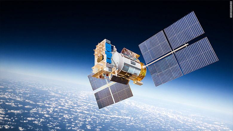
The GPS satellites are not so easy to target as people think (Installing "Trophy-system into satellites)


Picture I
https://avoimenkoodinmaailma.blogspot.com/

Kimmo Huosionmaa

GPS (Global Positioning Satellite) is a very good target for ASAT (Anti Satellite Weapons) because this satellite is giving the data for positioning for satellite-guided weapons like JDAM (Joint Direct Attack Munition) and GPS guided bombs and missiles. Those weapons allow that combat aircraft would close in the target in free angle, and that makes those weapons so effective.


The GPS is the easiest way to locate the position of the own troops, warships, and aircraft. GPS is also used in the safety systems of some special cargo, what are the risk to get stolen like money and the nuclear weapons. This system sends the location information of those things, and that will make the stealing that equipment very difficult.  If the security personnel would push the alarm button, that would send the information of emergency to the security company. And that's why GPS is the very vital role in the private or governmental security.


But if somebody would destroy the GPS-satellites the strike capacity of NATO task force will decrease, because the tactical support aircraft would need the precise information of own troops position. And that's why GPS-satellites are so important in those operations. But the use of ASAT-systems would cause big danger for those satellites. If the GPS-satellites are equipped with similar ADS-system, called "Trophy", what is used in the M-1 "Abrahms" tanks would that increase the probability of survivability, if the satellite would be getting attacked.


"Trophy"-type ADS is actually a microwave system, what uses multiple IR (Infra Red) sensors to detect incoming missiles, and then the microwave transmitter turns to those missiles, and the warhead of those missiles would be detonated too early. In the satellites that system might seem like some Sci-Fi space battle vehicle's gun turret. The similar system can easily install to the GPS-satellites, and that would allow destroying those incoming ASAT missiles. This would make some of those weapons unable to operate correctly. And that system would also be used against other satellites.

http://www.thedrive.com/the-war-zone/14966/images-emerge-of-m1a2-abrams-tank-equipped-with-trophy-active-protection-system

Picture I

https://i2.cdn.turner.com/money/dam/assets/150731152254-satellite-780x439.jpg

Thursday, June 7, 2018

The innovative emergency pill, what would call help for the people.


Picture I


Kimmo Huosionmaa

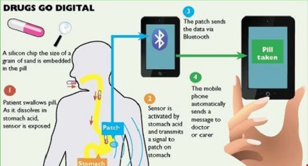
The NYPD has the first pill tracking system, what bases that the pills would be equipped with GPS-system. But there would be many more ways to create more sophisticated systems, what bases that technology. There could be the very bad thing for the pill like nitro pills, what are used for emergency, and that is that the person must call the emergency center or push some button for getting help.


Modern technology would give an opportunity for automatization of those processes. The answer would be the pill, what could be equipped with the transmitter, what can be connected to the smart telephone or some other system like GPS, and when the person would need help, could he just take the pill. The thing inside the pill or capsule would be the transmitter, what the person can eat, and then the stomach acid would activate the battery, what would give electricity for that device


When we are thinking about the use of this RFID-pill, in the point of view of the persons, who are working in dangerous situations and environment like forest guards,  those persons can have many types of those pills. And if the person would be attacked by some animal, could this person take the yellow pill, and that transmitter would send the code to the smartphone and satellites, that the attacker was an animal, and if the pill could be red, would the transmitted code tell, that the attacker would be human. The green code would tell that the injury would be caused by the normal reasons. This idea of the intelligent transmitter, what can be eaten, I got the song in 2525, and maybe the person, who created the NYPD surveillance system got the ideas for that invention from the same sources, and there is only one threat with that system. That is, that if somebody would break the system by hacking, would that lead the burglaries to the addresses, where they can find those medicals.


This part, where the people takes the information from pill would seem like pure fantasy, but in the real life those pills could involve the transmitters, what would send the codes to the mobile telephones, and those codes could call the quadrocopter to the place, and that system can transmit the information straight to person brains by using high power radio waves. In the scenario, where the person takes "information pills", one code could mean, that the person would need full preparation of the things, what have happened from the history of humankind, from the stone age to nowadays.


And this might be the very fascinating idea for the training of tomorrow. There is only one danger, that system could be weaponized very easily. There would be devastating results if those systems would be used to control people. If those drones would make two crossing radio signals, what are connecting in the human head, the electric arc would be devastating, when it burns the brain tissue. If this would happen in the amygdala, the person would be lost the own will immediately.


This is one way of seeing this kind of devices misuse. In some book, the personnel was closed in the mental hospital, and when they ate their pills, would everything be alright. They had one implanted microchip in their body, and another would be eaten by those patients. If this fictional system would see two codes, it would be let those persons continue their working, but if it sees only one code, it would use that radio wave for exterminating that targeted person.

Sources


https://www.troab.com/fda-approved-smart-pill-with-digital-tracking-system/

Picture I


Saturday, April 21, 2018

Why are the crop circles made almost every time in Great Britain?


Picture I
https://www.youtube.com/watch?v=u5CLrAG1j5M

Kimmo Huosionmaa

Below and above this text is links to document of crop circles, and the persons who are made some of them. If we have sharp  GPS-system and very good draw for the map, we can make very difficult and complicated crop pictures in the field. This technology consists a picture what would position over the crop field and then the GPS coordinates would be put on the system, and then the persons can do that without no difficulties. They just copy the picture to the field.

And if the persons would have drones with GPS system and very high power blowers of hydrocarbon-like Acetone, they could make those signs very easily. But when we are thinking about the movie below, we must ask why somebody did crop circles in 1678? if the reason for making those crop circles is that people would not go out to see some secret military aircraft, the reason for that news from 1678 is simple, that news could be faked by MI-5 (The Security Service), what could be responsible for some of those hoaxes around the crop circles.

Picture II


But there is another very important thing in this document. All crop circles are made in the areas, where is easy to go, and when we are thinking clearly, we must say that this kind of areas might be useful for delivering agents and special forces for missions against IRA. And some crop circles might cause the secret STEALTH aircraft operations, in the case, where some tornado comes from above, and that tornado can be forming because the STEALTH-helicopter would target the opposite rotating rotors to some place, and in this scenario the helicopters use the same kind of rotors as Kamov Ka-25 helicopters, what are used in Russian navy.

Those helicopters might look like saucers, and the rotors might be in the tube in the middle of the circular body.   And when we are thinking about the case, that some farmer in Australia has seen UFO over the field. There were not mentioned about the year when this person made the observation. But this farmer might see the airship hanging over the cornfield. Also, the British military has been tested airships for military use, and sometimes I have thought, that those Zeppelin-style airships were misunderstood as UFO:s.

Sources:

https://www.youtube.com/watch?v=u5CLrAG1j5M

https://en.wikipedia.org/wiki/Kamov_Ka-25

Picture I

http://metro.co.uk/2016/08/16/was-this-crop-circle-created-by-a-bong-company-6071443/

Picture II

https://www.chroniclelive.co.uk/lifestyle/nostalgia/geordie-engineer-who-built-real-1417186

http://crisisofdemocracticstates.blogspot.fi/p/why-are-crop-circles-made-almost-every.html

Wednesday, February 28, 2018

The use of mobile telephones as 3D scanners part II


(Picture 1)


https://www.instagram.com/p/BfbSDw5FIdC/

Kimmo Huosionmaa

The technology what makes the mobile telephones 3D-scanners is actually the same, what is used to make 3D maps of Earth and other planets. In that technology satellites use radars and meters range between satellite and planet, what makes possible to make those maps, and modern computers and radars allow to make high-resolution 3D-maps, what can be zoom in very good accuracy.


By using VLF or ELF  (Very or Extra Long Frequency) radars those satellites can make 3D maps from the ocean floor from the orbital trajectory. Same way ships can make 3D maps from the ocean floor, by using sonar systems. Also, Lidar or laser radars can be used in those mapping operations. Blue-green laser radars can scan very deep areas of the oceans, and that equipment can also meter the altitude and length of the waves.


But now I missed the thing, what I suppose to write. If the mobile telephones would be connected to drone-helicopters, and they could use enough sharp GPS-system, they could be used to scan very large areas. Of course, the system must know only the distance between the target and phone, and GPS is the very good tool to check the position of the telephone. But it could also work with triangle metering. The changes between the position of the drone and perfect circle can be the addition or subtract from the perfect circle.


That equipment works like satellites, but they are much smaller. And they can scan even entire buildings or ships by using their SONARS. So this might be new role fort smart telephones, what can now use in many things. And if that telephone would cover with waterproof cores and underwater drones it can use to scan entire fish, atolls or shipwrecks. Also, intelligence services can use those things to make 3D-models of submarines. Only thing what is necessary is that SONAR signal must pass the core.

Sources

https://www.instagram.com/p/BfbSDw5FIdC/

Picture 1

https://lmi3d.com/sites/default/files/phone_scan_04_0.jpg


Tuesday, February 27, 2018

How can the mobile telephone be used as 3D-modelling?


(Picture 1)


https://www.instagram.com/p/BfbSDw5FIdC/

Kimmo Huosionmaa

How can the mobile telephone be used as 3D-modelling? The answer to that question is simple. This thing uses the same device, what would focus lens of its camera. It also connects the data from the camera of that telephone. So this makes those mobile telephones very sophisticated tools for modeling. The problem of those scanners is that the mobile telephone must be absolutely stable, or the modeling would be failed.


But this can be solved by using selfie-stick, what is installed on the table or stable platform, and if the hands of the stable enough, the scanning can make by keeping the device in hand. But the fixing of this problem could be found from GPS. If this system would be sharp enough, the telephone could fix the errors, what shaking hands causes. In this solution, the GPS would map the place where the telephone is in the sharpness of only small part of the millimeter, and the computer would calculate the errors of the metering.


The system would take the original point, when scanning is beginning, and then it would fix the error what the shaking of hands might cause. This would be done by adding or subtracting the location in the real world of the phone, from the values of the pure ring. This would make the scanning more easier. This little program can revolutionize the CAM (Computer Aided Manufacturing) -technology.  Now any firm can buy this kind of equipment and use it as making 3D-models for CAD programs and 3D printers.


In this system, the computer in the mobile telephone transmits the distance between the target and telephone by using sonar. Sonar is almost as effective scanning tool as a laser, but the sound travels in the air much slower than air.


The optics of the mobile telephone would focus using Sonar and the situation where the user notices it is when this person wants to take a picture what portraits horizon. In this case, the system of the camera cannot get an echo from the surface, and the optics of camera cannot focus the image.


I have read some articles that same radars what are used in traffic light as traffic calculation sensors could be mounted to RPV-helicopters. Those helicopters can be used to make 3D-models of entire building areas. They use oblique scanning, what is connected to GPS and computing platforms to make 3D models of buildings. The computers would make 3D pictures by those pictures, what this device sends to computers.

Saturday, February 24, 2018

Attack against GPS or communication-satellites is a threat to any military force

X-37B
(Picture 1)


Kimmo Huosionmaa

Destroying communication satellites would cause the great danger to national security. If those satellites are unable to work, the strategic missile troops won't get launch codes. And the units that are on the field are unable to communicate with headquarters. That would make the strategic air support impossible and if that happens in the critical situation, could results be devastating. And all of the operations could be failed in this situation. Also, somebody might break in the command system, and starts to give false orders for troops. 


Dangers of using GPS-systems for military purposes is clear. The worst problem is that those satellites can be tracked and shoot to bites with high-altitude seat system. One version of this kind of operation is to use X-37B or similar shuttle, what is equipped with rockets. That shuttle can be installed example to the nose of Delta-rocket and connected with Agena stage, what gives it very good maneuver capacity. The rockets can be installed to this small shuttle cargo bay, on the top of manipulator's hand. 


And they can be shoot to target by aiming the system with optical telescopes. In this scenario, the shuttle could have similar rocket cassettes in the cargo bay, what are used in helicopters. Those cassettes can be used with manipulator's hand, what gives them greater freedom to choose the angle for that equipment, and the systems of that shuttle can link with other devices, like land-based radio-and optical telescopes and satellites, what are looking for targets.


 If those rockets would be used with the manipulator arm, the use of fuel during firing operations would be minimized. Turning manipulator arm doesn’t need fuel, and the rockets can fire in any direction. But there is another option for that shuttle. The same rockets that are used against satellites can be used as kinetic ammunition against targets on Earth. If they would be filled with ceramic warheads and shoot to the Earth, that would ammunition get the speed of 10-15 000 kilometers per hour. In that speed the impact energy will be very big, and those ammunition could be devastating. 


The use of rockets is more practical than machine gun because the rocket is the recoilless weapon, what doesn’t make shuttle unstable. Those rockets can also be installed in MKV:s (Miniature Kill Vehicles) or “space bazookas” what are about 50 cm. long and holds one to 5 rockets. They can shoot an orbiter with all rockets, and the aiming of that rocket is similar process than with shuttle. MKV:s could have CCD cameras, and they can use with or without the shuttle. They might look similar than normal helicopter rocket cassette, what is connected to small CCD-equipped telescope and maneuver unit. Those weapons are miniaturized versions of the satellites, what were developed in 1980’s. 


The thing what makes this more dangerous, than we ever though is that those GPS satellites can be replaced by hostile satellites. In this scenario, those destroyed GPS-satellites could be replaced by “Troy-horses”, what are similar satellites, but they would give wrong places for the equipment, what are connected to that system. In theory, those satellites can turn enemy own missiles against itself. This means that enemy cruise missiles can be programmed to attack its own cities. That kind of treats is possible in this modern era of the military. The enemies would not know, that some of their satellites have been destroyed. 


But also the GPS-satellites can have resist-weapons. Those satellites can equip with “gyrojet guns” and rockets or shotguns, what gives them the capacity to defend themselves against the strikes. The problem of powder weapon, in this case, is that there must be burned same size of powder in opposite direction, where the gun is aimed. Also, electromagnetic shields like micro- or radio-wave EMP-weapons can be used to make those miniature kill vehicles unable to operate. Those weapons can installed in any satellite or space station. They can operate independently, and their operations would not be connected to that satellites normal functions. The defensive weapons work like offensive weapons, but their targets are anti-satellite weapons, what is attacking the satellite. 

Sources


Picture 1

The MMX mission aims to collect a 15-gram sample from Phobos. It is on the way to Mars.

“This artist's concept of JAXA's Martian Moons eXploration (MMX) mission shows the deployed spacecraft, Mars, and Mars's largest...